Borders
From Negatives Preserved, research & archive
DVAA, Delaware Valley Arts Alliance, Narrowsburg, New York
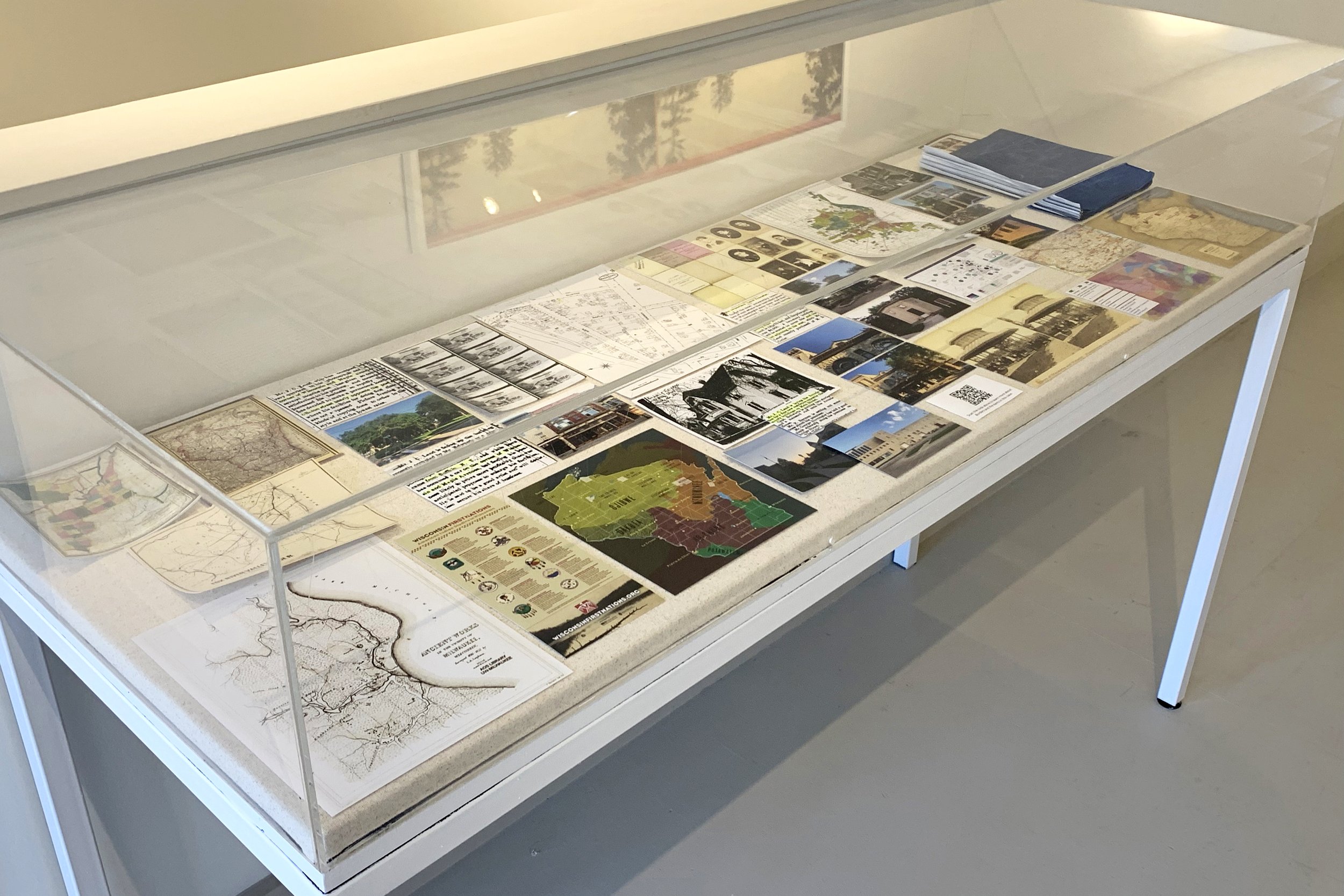
Borders is an archive of research materials, historical maps, replicas of photographs by J.C. Land, photographs by Stephanie Land, of her time in Waukesha, Wisconsin in August 2021.
What appears to be a map is actually a history of violence. Lines are drawn and borders are created to uphold systems of control and power. A map is also a point a view, created by a ‘maker’.
There are millions of Black and brown Americans and Indigenous populations, who do not have an archive available to access due to the impact and legacies of Indigenous genocide and American slavery. A white family’s archive in the US is embedded within a white supremacist system that has defined the parameters of value to history and memory.
Thank you to the Waukesha Historical Society Research Center for providing the space and time for me to research the archive of J.C. Land.
Map of the Settled Part of Wisconsin Territory, from Traveller's & Emigrant's Guide to Wisconsin & Iowa. By Henry I. Abel. Accompanied With A New and Improved Map of those Territories. With The Addition of Parts of Illinois, Indiana, and Michigan, 1838. Courtesy of David Rumsey Map Collection, http://www.davidrumsey.com/maps3687.html
Ancient works in the vicinity of Milwaukee, Wisconsin, surveyed in 1836-1852 by I. A. Lapham ; T. Sinclair’s Lith. From book entitled: "Antiquities of Wisconsin as surveyed and described, 1855." [Plate] III. Courtesy of University of Wisconsin Milwaukee Libraries, https://collections.lib.uwm.edu/digital/collection/agdm/id/58/rec/1
![Lipman & Riddle & Fox River Valley Railroad. (1857) Fox River Valley R.R. in Wisconsin with its connections. [Milwaukee] [Map] Retrieved from the Library of Congress, https://www.loc.gov/item/98688662/.](https://images.squarespace-cdn.com/content/v1/5e549fc686f8153e0ce38795/e46da830-a607-4846-8539-997c04e91888/DVAA_Archive+Case_Fox+River_maps_12733_extralarge.jpg)
Lipman & Riddle & Fox River Valley Railroad. (1857) Fox River Valley R.R. in Wisconsin with its connections. [Milwaukee] [Map] Retrieved from the Library of Congress, https://www.loc.gov/item/98688662/.

Rand, McNally & Co.'s Wisconsin, 1879, Rand McNally and Company. It was estimated that J.C.Land moved to Waukesha in the late 1870's and this is what Wisconsin would have mapped out to look like then. Courtesy of Wisconsin Historical Society.
From website Wisconsin First Nations. To learn more visit: https://wisconsinfirstnations.org/current-tribal-lands-map-native-nations-facts/
From The Ways website: https://theways.org/map. "The Ways is an ongoing series of stories from Native communities around the central Great Lakes. This online educational resource for 6-12 grade students features videos, interactive maps, and digital media exploring contemporary Native culture and language. The Ways supports educators in meeting the requirements of Wisconsin Act 31, seeking to expand and challenge current understanding of Native identity and communities. The Ways is a production of PBS Wisconsin Education."

Freeman Newspaper clipping, 4-24-1879, Courtesy of Waukesha County Historical Society, Huelsman Family Research Center.

Land, Stephanie, 2021, Wisconsin and Maple, Cutler Park, Waukesha, Wisconsin. Photograph of the corner where JC Land had parked a 'traveling' photo studio before he purchased the brick and mortar studio on Clinton Street. Estimated date 1878-1880.

Freeman Newspaper clipping, 5-21-1879, Courtesy of Waukesha County Historical Society, Huelsman Family Research Center.

Photographer Unknown, Clinton Street, Waukesha, WI. Courtesy of Waukesha County Historical Society. The only known photograph of JC Land's photo studio on Clinton Street, estimated dates 1880-1893.

Land, Stephanie, 2021, Clinton Street, Waukesha, WI. Photograph of the site where JC Land's photo studio stood in the 1880's. The building currently standing was built in 1893, assumed to be the building that replaced the photo studio.
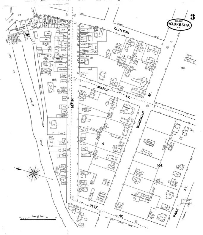
Waukesha Map, 1890, Courtesy of Waukesha County Historical Society

Photographer Unknown, 1914, Photograph of J.C. Land's house on Main Street, Waukesha, Wisconsin, Courtesy of Waukesha County Historical Society

Freeman Newspaper clipping, 4-21-1888, Courtesy of Waukesha County Historical Society, Huelsman Family Research Center. The clipping reads "Improvements on Main Street. Mr. J.C. Land is laying the foundation for a fine new residence opposite the county buildings on Main Street"

Land, Stephanie, 2021, Main Street, Waukesha, WI. Recreation of a photograph J.C. Land originally took from the top of the Courthouse. This photograph is the location where J.C. Land's house on Main Street stood, it would have been on the right side of the street near the highest steeple point.

Land, Stephanie, 2021, Former location of the Weber Land Brewery, Grand Street, Waukesha, WI. Photograph of the landmarked Weber brewery that J.C. Land co-owned for a few years in the 1980's, after marrying into the Weber family.
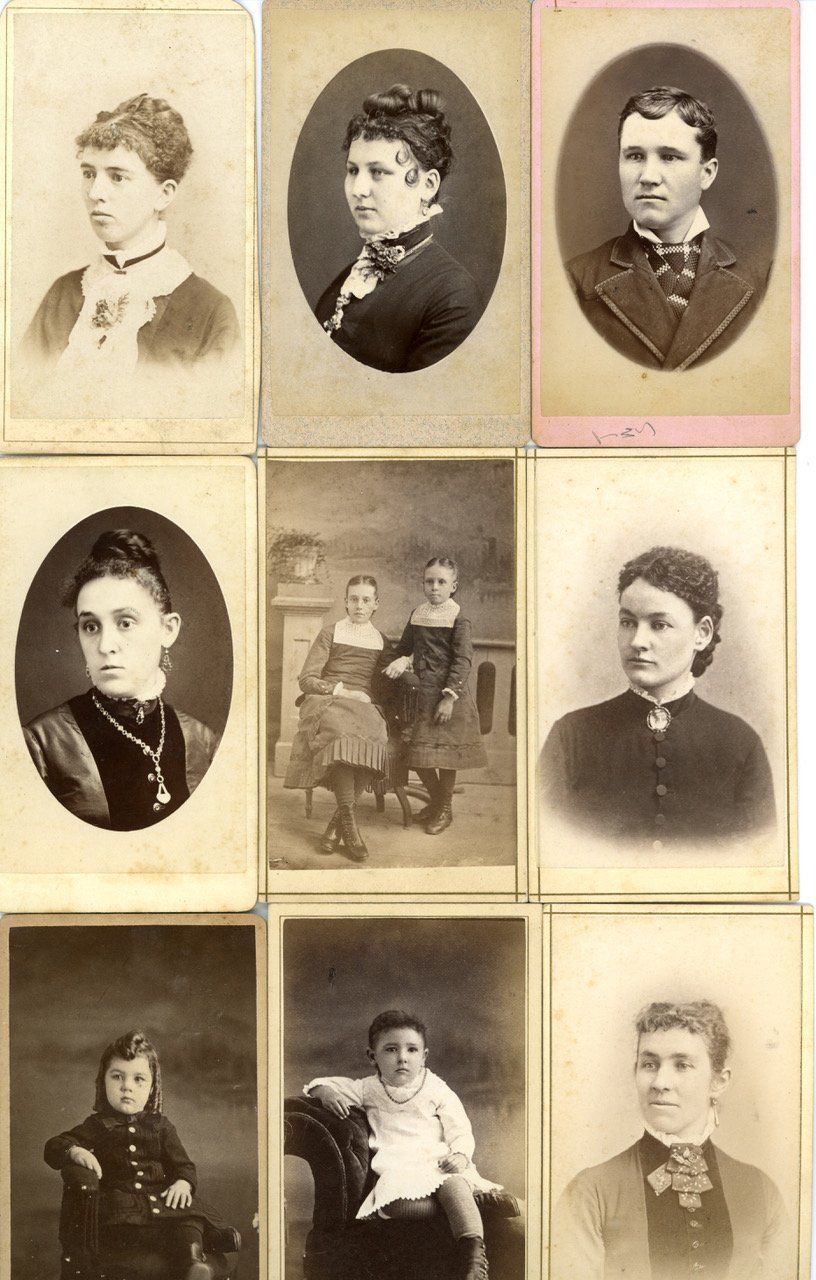
Land, J.C., Portrait Cards, Waukesha, Wisconsin, estimated date 1878-1890, Courtesy of Waukesha County Historical Society
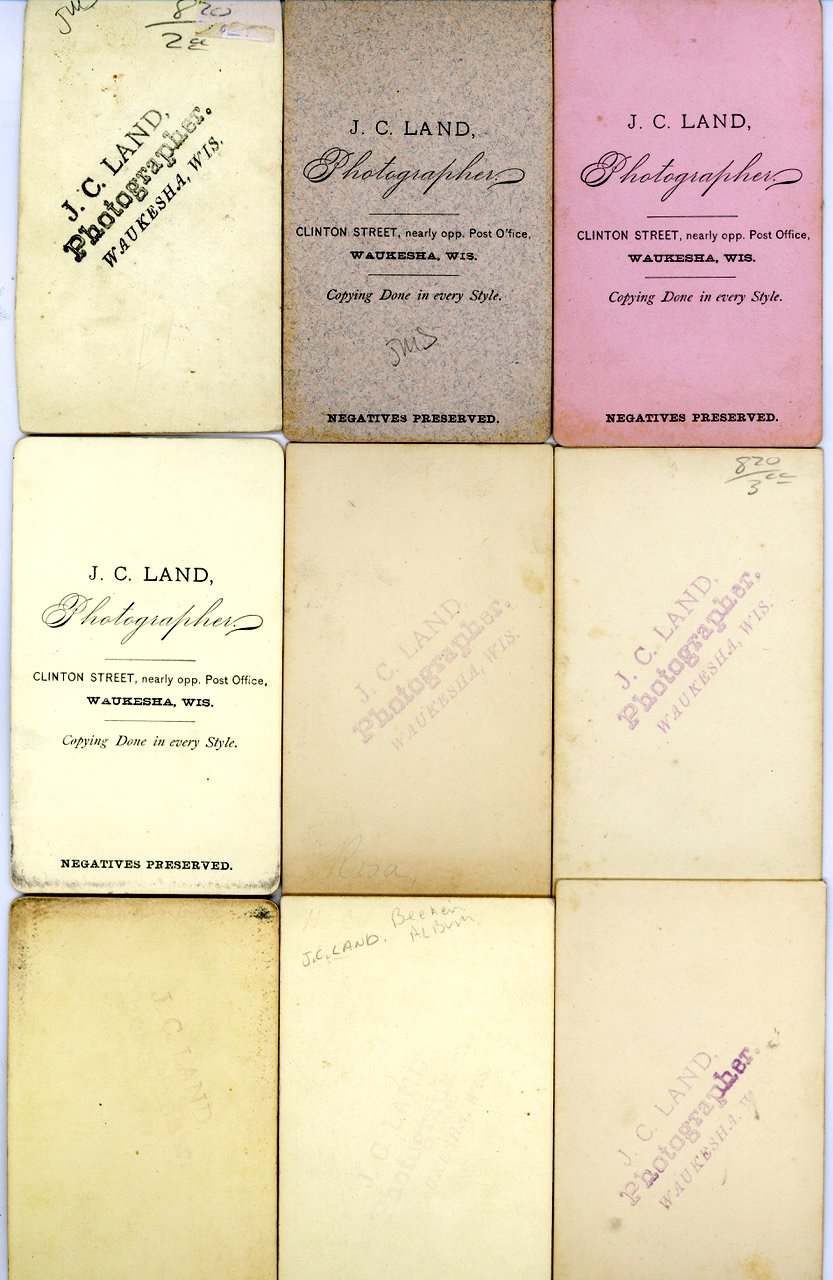
Land, J.C., Portrait Cards (back), Waukesha, Wisconsin, estimated date 1878-1890, Courtesy of Waukesha County Historical Society

Freeman Newspaper clipping, 8-17-1888, Courtesy of Waukesha County Historical Society, Huelsman Family Research Center.

Land, Stephanie, 2021, Main Street, Waukesha, WI. Detail of the building built in 1888, assumed to be JC Land's place of business for a bar.

Land, Stephanie, 2021, Main Street, Waukesha, WI. Photograph of two buildings at one time owned by JC Land, noted from the found Freeman newspaper clippings. The building on the left was built in 1888 and held a bar, saloon and possibly pool hall. The assumption is the photo studio closed and JC Land went into business here.
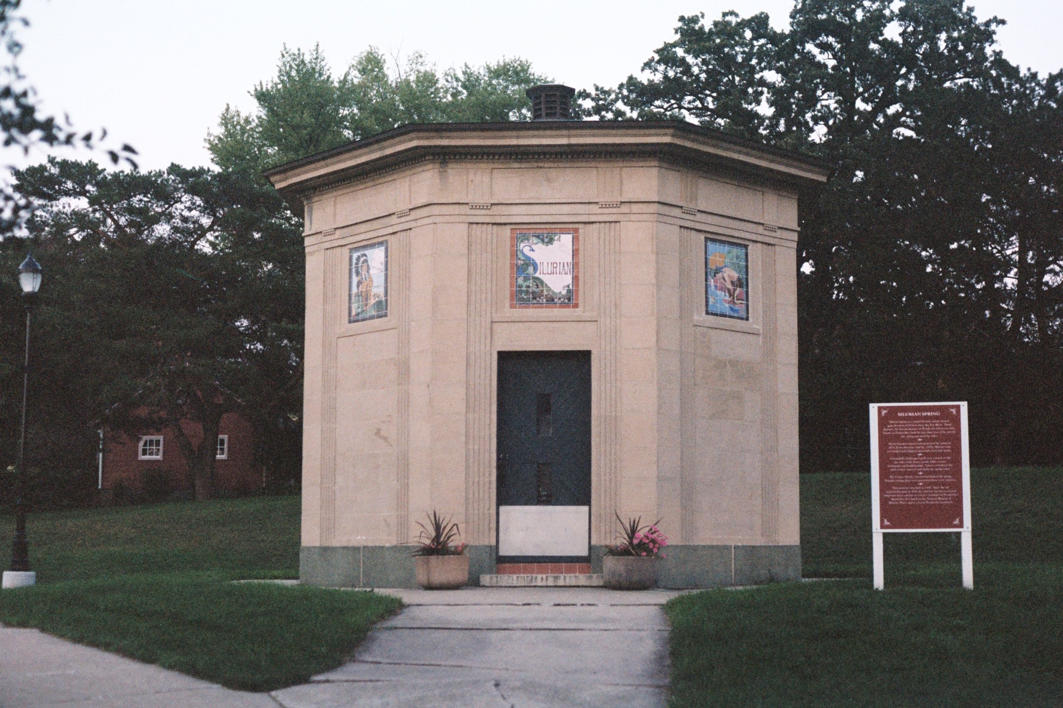
Land, Stephanie, 2021, Waukesha Springs Park, Waukesha, WI. Photograph of the landmarked Sirulian Spring, where the original Springhouse stood, seen in JC Land's stereograph.

Land, Stephanie, 2021, Fox Riverwalk, Waukesha, WI. Photograph of a current day recreation of Waukesha's Springhouse. Original location was in Waukesha Springs Park, shown in JC Land's stereograph.

Land, J.C. Stereograph taken at the original Springhouse, Waukesha, Wisconsin, estimated date 1878-1890, Courtesy of Waukesha County Historical Society
From website Mapping Inequality: Redlining in New Deal America. Mapping Inequality was created through the collaboration of three teams at four universities, visit their site to learn more: https://dsl.richmond.edu/panorama/redlining/#loc=11/43.03/-88.136&city=milwaukee-co.-wi

From Waukesha redlining map by Cartographer Marci Mitchell
Screengrab from native-land.ca showing the Indigenous nations who originally lived and farmed the land now called Waukesha, WI. Visit native-land.ca to learn more.

Photographer unknown, 1920s-1940s, Grand Street, Waukesha, Wisconsin. Photograph of a building owned by J.C. Land, (see LAND carved in stone above the doorway) found by the Waukesha County Historical Society Research Center.

Land, Stephanie, 2021, Grand Street, Waukesha, WI. Photograph of a building built and owned by J.C. Land. Only known to be owned by Land because of a photograph found with his name carved above the door. Assumed ownership early 1900's-1930's.

Land, Stephanie, 2021, Perkins Avenue, Waukesha, Wisconsin. Former house where my father was born and raised

Land, Stephanie, 2021, Waukesha County Historical Society, Waukesha, WI. Photograph taken while in the Research Center, of Stephanie's hand, looking down at the original stereographs taken by JC Land, with a file folder titled Land/Stroebel, with geneaology archives.

Land, Stephanie, 2022, Blueprints of accumulated paths walked while retracing the steps of Stephanie's great-great-grandfather, JC Land, in Waukesha, Wisconsin.
From a website about the history and current day of sundown towns across America. Created by historian James W. Loewen. On the map sundown towns in Wisconsin are highlighted in orange, courtesy of https://justice.tougaloo.edu/location/wisconsin/ Recommended reading is James W Loewen's book titled 'Sundown Towns: A Hidden Dimension of American Racism"
From website Wisconsin First Nations. To learn more visit: https://wisconsinfirstnations.org/current-tribal-lands-map-native-nations-facts/


![Ancient works in the vicinity of Milwaukee, Wisconsin, surveyed in 1836-1852 by I. A. Lapham ; T. Sinclair’s Lith. From book entitled: "Antiquities of Wisconsin as surveyed and described, 1855." [Plate] III. Courtesy of University of Wisconsin Milwau](https://images.squarespace-cdn.com/content/v1/5e549fc686f8153e0ce38795/98659212-e816-4b6f-b527-dcec1b538878/DVAA_Archive+Case_Ancient+Works.jpg)


